Unlock the Editor’s Digest for free
Roula Khalaf, Editor of the FT, selects her favourite stories in this weekly newsletter.
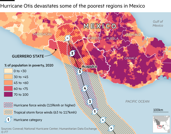
A hurricane of record intensity that smashed into the Mexican coast near the resort of Acapulco and caught authorities unprepared has left at least 27 people dead.
Images on local media showed swaths of the city of around 800,000 people had been flooded, with the roofs of houses ripped off and trees snapped. Many communities were left without communication or electricity for hours. The main highway into the city was blocked by landslides.
Thousands of soldiers and marines had been deployed and there was a large reconstruction effort, President Andrés Manuel López Obrador said.
Hurricane Otis presented a “nightmare scenario” for southern Mexico, according to the US National Hurricane Center, because it strengthened at an extraordinarily fast rate, leaving little time for authorities to respond.
“There are no hurricanes on record even close to this intensity for this part of Mexico,” said Eric Blake, the centre’s senior hurricane specialist.
Within 24 hours Otis went from a tropical storm of under 100km per hour (60mph) to a Category 5 hurricane, the highest on the Saffir-Simpson scale, and slammed into the coast with maximum sustained winds of 270km per hour (165mph).

Waves of more than 10m in height were cited by Mexican authorities, and local television stations and images on social media showed swamped streets, flooded hospitals and even destroyed furniture in hotel rooms.
The full extent of the damage was still unclear, even to government leaders and authorities, as communications remained disrupted.

Acapulco, a city of around 800,000 people on Mexico’s south Pacific Coast, is in Guerrero, one of the country’s poorest states. The city once associated with Hollywood glamour plays host to luxury resorts favoured by residents of capital Mexico City, but now has more than half of its population living in poverty, according to government statistics.
Scientists have warned that climate change intensifies weather patterns, leading to more extreme heatwaves, droughts and storms. During hurricanes, the warmer temperatures mean more moisture is held in the air and then released as rainfall.

The El Niño weather phenomenon, which warms the water over the Pacific Ocean, exacerbates the extreme conditions as it pushes more heat into an already warmed atmosphere. The past four months have already proved to be the hottest on record globally, with sea surface average temperatures also at their peak.
The US National Hurricane Center’s Blake described on social media feeling “sick” watching Otis develop from a moderate tropical storm to a Category 5 hurricane in less than 24 hours.
It was difficult to know immediately what drove the hurricane to increase in intensity so quickly despite the weather models not forecasting it, said Phil Klotzbach, senior research scientist at Colorado State University.
“Otis really blew up,” said Klotzbach. “There is rapid intensification — and then there is what Otis did.”
Otis follows just weeks after hurricane Lidia hit near the beach resort of Puerto Vallarta, also on the Pacific Coast, after it rapidly strengthened to Category 4.
The NHC was also tracking post-tropical cyclone Tammy across the Atlantic and Caribbean this week, as it weakened after five days as a hurricane, noting it was still producing winds of 140km per hour (85mph).
Scientists at the US National Oceanic and Atmospheric Administration in August increased their prediction for the 2023 Atlantic hurricane season to be “above-normal”, due to record-warm sea surface temperatures.
Cartography by Steven Bernard
Climate Capital

Where climate change meets business, markets and politics. Explore the FT’s coverage here.
Are you curious about the FT’s environmental sustainability commitments? Find out more about our science-based targets here
Credit: Source link


